 |
| Water, freeway, electrical power, probably a cellular phone tower or two as well. The Schuylkill River from the South Street Bridge, Philadelphia. |
05 December 2010
corridors

17 November 2010
inclusion/exclusion in the city

From the chapter "Neobourgeois Space":
What novelists like Perec, Beauvoir, and Rochefort -- no less than the Situationists performing their urban experiments in Paris during the same years, or Henri Lefebvre progressively recoding his initial concept of "everyday life" into a range of spatial and urban categories -- realized, was the emergence of a new image of society as a city -- and thus the beginning of a whole new thematics of inside and outside, of inclusion in, and exclusion from, a positively valued modernity. Cities possess a center and banlieues, and citizens, those on the interior, deciding who among the insiders should be expelled, and whether or not to open their doors to those on the outside. -- Kristin Ross, from Fast Cars, Clean Bodies p. 149 - 150What interests me about Ross's point, in the context of mobile connectivity and infrastructure, is how this inclusion/exclusion is reinforced through access to communication technologies. The ease of wayfinding through a mapping app on a smart phone is only useful if you can access the phone and afford the data plan. Is access to a smart phone a new inclusion into "positively valued modernity"? And how is this access opened to outsiders? The urban spaces have not changed much due to mobile connectivity, but the utility they spaces hold changes through on-the-go access to the Internet, for instance, through a smart phone. Perhaps mobile and urban technologies can become more open and inclusive -- here is an example of public usb drives installed in New York City -- but, most likely, inclusion in urban society will necessitate leaving the phone in the pocket, inhabiting the physical city and not the cyber-city, and spending more time on the streets, on foot.
08 November 2010
the invisible city
 |
| One Wilshire in downtown Los Angeles, a prominent colocation point on the west coast/eastern shore of the Pacific Ocean for global telecommunication providers. photo by Xeni Jardin, via flickr source |
Kazys Varnelis's work, especially The Infrastructural City: Networked Ecologies in Los Angeles, is extremely useful for conceptualizing the space of telecommunications. In looking over his essay on One Wilshire in The Infrastructural City again, I found this quote:
If the [Disney] Concert Hall represents late capitalism's obsession with the visual, One Wilshire represents the rise of invisible networks and unmappable forces in our lives. The invisible city that grows from telecommunications is, by and large, a privatized infrastructure, its possession by private forces making it impossible to map. Although the postmodern hyper-space of the Bonaventure [Hotel] is unmappable by the body, a legible floor plan can still be found. No such plan exists for networked capital. Diagrams of the Internet and of fiber optic lines are hard to find: the data is proprietary, a matter too important for corporations to allow free access. Moreover, the complexity emerging along with the massive proliferation of connections increasingly makes it hard for even corporations owning the networks to understand their dimensions. A floor plan of One Wilshire tells you little about what happens there. Even for the corporate hive mind, the map is exceeded by a hypercomplex reality. The space of global technological flows does not desire to become visual or apparent: perhaps only some spray-paint [on asphalt] or a flag in the ground marks the presence of fiber below, and sometimes even that is elusive. (pages 128-129)Increasingly, conceptualizing the spaces of this invisible city require searching through pages upon pages of planning documents unearthed on the websites of municipalities to infer where a fiber-optic cable is run underground and which global corporation is putting it there. This research is done more through identifying the spaces where conditions come together than by identifying the direct points or locations of the telecom infrastructures.
 |
| Telecommunication networking equipment inside One Wilshire. photo by Xeni Jardin, via flickr source |
25 October 2010
live, global locations of cableships
 |
| The locations of the world's submarine fiber optic repair ships, 25 October 2010. Source |
11 October 2010
submarine fiber optic cables attacked by sharks
View Larger Map
In the 1980s AT&T was prototyping submarine telecom cable by laying they between the Canary Islands, where the cables were attacked by crocodile sharks
Buried in the final section of a Rand Corporation study into the feasibility of a new platform for deep-sea submarines, is a chapter about the history of submarine cable infrastructure. In an otherwise dry paragraph about the dangers from dragged anchors and the like that submarine cables face on the ocean floor, was this sentence:
"Between 1985 and 1987, AT&T found that its first deep-sea submarine fiber optic cable (laid between the Canary Islands, Grand Canaria and Tenerife) suffered periodic outages because of frequent attacks of the Pseudocarcharias kamoharai, or crocodile shark, on the cables."
 |
| The crocodile shark. Source |
A footnote goes on to explain that "The electric fields of which, it was thought, duplicated that of the shark’s prey under attack."*
I find this fascinating, and slightly amusing, that the globally networked fiber-optic communication system could be damaged enough to cut out by a shark attacking the cable. Information and communication technologies exist as physical abstractions, of data flows between New York and London's financial centers that dictate the rise or fall of the day's stock trades, and out of nowhere the infrastructure could fail because of a hungry and/or angry shark, at the bottom of the Atlantic Ocean.
*source: Martin, Rick, “Life History and Behavior of Lamnoid Sharks,” from ReefQuest Expeditions, 2001.
10 September 2010
corn fields and fiber optics in the Midwest
 |
| Fiber optic line markers alongside Highway 24 west of Eureka, Il. |
 | ||||
| Stop sign, street sign, and fiber optic cable route marker. Eureka, IL |
 | ||
| Buried gas, sewer, electric, and communication infrastructure, and the overhead electrical lines. Eureka, IL |
What caught my eye and why I stopped to take these photographs, was this scene above, where it appears some digging was scheduled in the near future. The spray paint and mini flags signify all the different buried infrastructure lines. What seemed somewhat unique here was that the flags had the company's name on it. Orange for communication, red for electricity, yellow for gas, green for sewers. This is an instance of invisible, underground systems poking through to the surface, if only for a short time.
 |
| A close up of these utility flags -- gas and fiber optic lines. Eureka, IL |
10 August 2010
a cathedral for electricity
In a space fit for worship lost somewhere in the far, far metropolitan fringe of Northern California, is a decommissioned hydroelectric power plant, the building now used for the storage of dusty, forgotten outdated equipment. The space's original utility was to produce electricity for an industrializing Bay Area and Central Valley, but now it sits vacant, in need of structural repair and earthquake retrofitting.
 |
| The main room of the building. Note the railroad tracks on the bottom left, and all the windows letting in plenty of natural light -- no reliance on electrical lighting even though electricity was being produced in this space. Photo by Alan Wiig. |
 |
| Used Pelton wheel turbines -- hydraulic mining technology now used to generate hydroelectric power. |
 |
| Old signage letters -- look at that font! |
 |
| Antique equipment. The truck was deteriorating but in decent shape. The covered frame center left is possibly from a San Francisco horse-car, the pre-cable car form of urban transit that Chris Carlsson wrote about recently on Streetsblog SF. |
 |
| The view of the holding reservoir right outside the power plant. Swallows now roost throughout the building, gaining entry via broken window panes. Their cries echoed throughout the main room during our visit. |
03 August 2010
entry points to the urban underground

Photos taken last winter on the University of Pennsylvania's campus. I was struck by the variety of shapes and sizes of the cast iron circles, as well as how prevalent these access points are around the campus.
Looking at the patterns of squares and circles was, at the time, something to do to distract myself from all the snow that had
recently fallen. Now, in early August, winter seems like a distant memory.
mapping submarine fiber-optic cables
 |
| Telegeography's Global Submarine Cable Map 2010 |
Yesterday, via an article on The Economist magazine's website, I found out about Greg's Cable Map, which is an excellent mash-up of submarine fiber-optic cable landing locations layered onto Bing Maps. The map effectively shows where the Internet enters and leaves each of the continents and most, if not all, of the inhabited islands in between. While the global scale submarine cable map can be seen and even downloaded as a jpeg file at Telegeography's website, Greg's Cable Map is useful because it allows the viewer to zoom in to see the particular cities where the various submarine cables emerge from the ocean floor and connect into the terrestrial Internet grid.
Greg has also provided links to each submarine cable's owner-operator, so it is possible with a little research to see who is routing what through where regarding the major Internet Service Providers. For instance, in Tuckerton, New Jersey, just north of Atlantic City, two cables land, the TAT-14 and the Atlantica 1. At the TAT-14 website, there is a list of the thirty four companies that are partnered with Sprint to use the TAT-14 cable system to route Internet traffic. While this side of the Internet is not slick and fancy, and the websites often appear ten years out of date, the information about the submarine cable systems is interesting and important. It places in distinct space the ephemerality of bits of information traveling over the Internet's global network. In effect, it is the global network grounded in specific locations, like Tuckerton. Amid the sprawl of suburban New Jersey, on the border of the Pine Barrens, is a landing point for a cable that, while anonymous and indistinct, forms part of a global communication network that we all rely on daily. Effectively, Tuckerton is part of the everyday landscape of the Internet that is accessible through the screen of our computer or mobile phone, but also present in submarine cables like the TAT-14.
 |
| Tuckerton, New Jersey, the landing point of two submarine fiber-optic cables. Image taken from cablemap.info |
...a final note -- after looking at the map, I am almost positive that the map does not show the actual location of the landing point. Finding these actual spots would require some fieldwork that I hopefully will be able to begin this fall.
10 July 2010
cellular phone infrastructure in Philadelphia
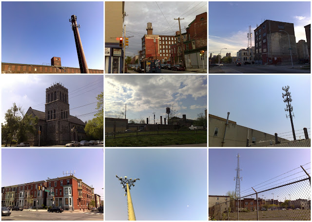 |
| A small selection of cellular phone sites throughout Philadelphia. Top to bottom, left to right: Washington Ave around 22nd St.; off 5th St. north of Spring Garden; 6th St at Spring Garden -- note the rectangular transmitters on the roof of the building and Verizon's large tower in the background; transmitters on top of St. Peter's Church of Christ at Kingsessing Ave. and 47th St.; North Broad St. near Erie Ave.; South Philadelphia near Front St.; South Broad St.and Tasker St. with cell site directly on top of an apartment building; Spring Garden between 3rd St. and 4th St.; off 13th St. just north of Washington Ave. (for a larger version of the image, click here |
As the utility of cell phones increases, especially as they become mobile, pocketable, Internet-ready computers, the web of infrastructure required to keep these devices connected (I hesitate to even call them phones since they multi-task so extensively) increases. To have a signal strong enough to check one's email or location requires a cell site close nearby, wherever and whenever that location is. Consequently, these in-between, interstitial non-spaces, wedged in at the edge of a major freeway off-ramp for instance, or on top of an apartment building or church, become integral to all of our everyday lives. When people rely on an always-on connection to a communication network, the geography of these spaces of radio-signal transmission become as important as the asphalt and concrete geography of the city.
There is plenty to write about this, so stay tuned and I will make an attempt this summer to post more often...thanks for reading.
25 May 2010


21 May 2010

13 April 2010
Creating the Digital City: Geographies of the Internet's Infrastructure

(click on the image to enlarge)
A collage of photos of data centers and colocation points. photos by author; left to right from top down: Digital Realty Trust at 833 Chestnut, Philadelphia; 365 Main at 720 2nd St, Oakland (the large white building in center distance); 60 Hudson St, New York City; 365 Main at 365 Main St, San Francisco; Quonix Networks at 2401 Locust St, Philadelphia; Terminal Commerce Building (on the left) at 401 North Broad St, Philadelphia; Level 3 Oakland at 1313 53rd St, Emeryville.
A collage of photos of data centers and colocation points. photos by author; left to right from top down: Digital Realty Trust at 833 Chestnut, Philadelphia; 365 Main at 720 2nd St, Oakland (the large white building in center distance); 60 Hudson St, New York City; 365 Main at 365 Main St, San Francisco; Quonix Networks at 2401 Locust St, Philadelphia; Terminal Commerce Building (on the left) at 401 North Broad St, Philadelphia; Level 3 Oakland at 1313 53rd St, Emeryville.
This coming Sunday I will be presenting at the Association of American Geographers 2010 Annual Meeting in Washington, DC. My abstract is below; the image above is a collage of some of the photos that make up my research over the past few months into the landscape of cyberinfrastructure. If anyone reading this is able to come to the session, please introduce yourself.
Creating the Digital City: Geographies of the Internet's Infrastructure
is part of the Paper Session:
Theorizing the Digital City
Abstract:
The digital city is here, and although this space has been theorized for at least a decade, there is little research into the infrastructural networks that support these emergent urban landscapes. While geographers have critically examined the role of traditional infrastructures—water, sewer, streets, electricity, and telephone—in creating modern cities, little attention has been paid to the role of the Internet's infrastructure in creating urban spaces today. The geographers that directly study the Internet have traditionally done so either from an economic geography standpoint or from the perspective of the utility of the cyberspace itself. This presentation aims to address how the Internet reaches our computer screens and mobile phones via the infrastructural networks that ground the technologies in the urban landscape. This presentation will situate the social and spatial impacts of the digital city's physical infrastructure: the data centers and fiber optic cables as well as the hertzian spaces that merge to provide ubiquitous Internet connectivity for the contemporary city. For example, what is the historic development of urban data centers: where are they sited and why, and how do these businesses interact with their surroundings. The methodological utility of different theoretical approaches, ranging from urban political ecology to postmodernism, will be critiqued and then applied using central Philadelphia as a case study. Understanding how we conceptualize proximity and how the scale and interdependence of interactions are fundamentally changing within these networked ecologies is a needed component for studying urban spaces today and into the future.

27 March 2010

12 March 2010
Terminal Commerce Building's power supply

a view from the backside of the complex, and shows some of the
electrical infrastructure needed to keep the data center running.

22 February 2010

14 February 2010
data centers taking over New Jersey?
The New York Times real estate section had a piece by this past week by Jotham Sederstrom: North Jersey Finds Popularity as Home for Data Centers. In this down economy, on one of the few growing real estate markets is in the construction of data centers. In New Jersey two million square feet of data center space is in some stage of construction. Multiply that by average costs of $1,200 per square feet, and you have $2.4 billion dollars going into this industry in New Jersey alone. The reason northern New Jersey is quickly becoming home to this industry is its close proximity to New York City, but without the immense real estate costs associated with building in the city itself. To quote the article at length:
"Data center providers and industry analysts said that North Jersey was an ideal location for the data needs of New York City’s large financial services industry. In a business that does countless transactions in a second, a greater distance would add milliseconds to every action taken online, but if the center is situated too close to Manhattan, construction costs can soar. Michael Boccardi, chief executive of Cervalis, a 10-year-old data center provider with facilities in Connecticut and New York State, said his company chose a site in Passaic County for its first New Jersey facility for those reasons.
“We felt that we wanted to be close but not too close, but still within that core 25-mile vicinity of New York City,” Mr. Boccardi said of the 150,000-square-foot operation, which he said would open by the end of the month and accommodate many of the financial services firms that were affected by Sept. 11."
That financial service firms located in lower Manhattan will soon exist partially in north Jersey is a strange element of contemporary, digital urbanism: the urban is not just connected to the suburban Passaic County through workers commuting into New York City, but also through the instantaneous, continual transmission of data back and forth between the offices full of workers but little computer equipment, and the data center, full of equipment but very few employees.
View Larger Map
Above is the satellite map of the location of 5851 Westside Avenue, North Bergen that the Times article focuses on. It is just two miles west of the Hudson River, across a bit of marshland from the New Jersey Turnpike. As urban society becomes more and more digital, the data that these actions produce has to be stored somewhere, often in places like this one.
06 February 2010

05 February 2010
The Infinity, 365 Main, and the USPS Embarcadero Postal Center

Here is a pretty interesting urban juxtaposition to be found in downtown San Francisco. On the 300 block of Main Street, between Folsom and Harrison, there is a luxury condo complex at 333 Main called The Infinity, the original and namesake 365 Main data center at 365 Main, and across the street, the Embarcadero Postal Center, which is entered around the corner at 226 Harrison. The luxury condos provide downtown living for some agents of gentrification, 365 Main houses a portion of the the Internet, and the USPS facility organizes then delivers non-electronic mail. This situation is representative of 21st century San Francisco's digital city. It is a mixture of high-tech economy, housing that is out of reach for much if not most of the city's populace, and an analog holdout in the form of the Postal Service. While it is likely that someone who works at 365 Main lives at The Infinity, I would be surprised if anyone at the USPS facility could afford to live there.
By the way, if anyone walks by 365 Main to take a picture of the building, be prepared for security to come out and tell you that you cannot photograph it, even if you are on the public sidewalk, which San Francisco defines as such: "Public right-of-way is defined as all City roadways and sidewalks bordered by private properties, (improved and un-improved.)" Source
02 February 2010

23 January 2010
lots of wires

I can see fiber optic cabling, a petroleum pipeline, some electricity equipment in the middle-ground of the photo, and barbed wire above the chain-link fence.
14 January 2010
wires and tubes: submarine fiber-optic cable journalism from Wired Magazine

An old MCI do-not-dig-here marker for a fiber-optic cable laid alongside the railroad tracks in Berkeley, California. Photo by author.
Way back in 1996, when the Internet was yet to be found in our pockets and was likely accessed by dial-up modems, the sci-fi/cyberpunk/etc writer Neal Stephenson (who has a Bachelors in Geography from Boston University according to Wikipedia) wrote what has to be one of the longest pieces Wired has published--62 pages formatted to print on standard, 8.5'' x 11'' printer paper--about the laying of what was then the longest wire in the world, connecting Europe with East Asia and points in between. The writing is great and very informative. Stephenson calls himself a "hacker tourist" as a way to circumvent both journalistic standards and scholarly language, creating a picture of what it takes, or took in 1996, to lay the fiber-optic infrastructure that allows the Internet to function around the globe. In the intervening 14 years, the amount of submarine cables have increased tremendously. Edward Malecki published an article on the subject in the Annals of the AAG a year ago, and yet that article, while useful, does not get at the on-the-ground reality of what it takes to lay and maintain the cables in the way Stephenson's essay does. "Mother Earth Mother Board" is archived at Wired's website and is free to access. I am working my way through it now and am thoroughly enjoying it.
06 January 2010
water and electrical infrastructure

Here is a view of Moccasin's reservoir:

The water leaves the hydroelectric plant to the right of the picture and travels under the mountain to the left, eventually making it to the sinks, showers, and lawn sprinklers of San Francisco.
visualizing data centers
In researching data centers and co-location facilities this morning, I came across two well-done sources of videos that explain some of the spaces of the Internet. 365 Main, which is based in San Francisco but manages data centers around the US, has what I would consider a surprising amount of transparency regarding their operations and facilities. They have posted a series of short videos about their original location, at 365 Main St in downtown San Francisco. I will post some of my own pictures of their facilities soon, but in the meantime, check out these videos. The second source is Digital Realty Trust, which has a "knowledge library" of white papers, videos, and other sources for information on their business building data centers. Mixed in with the more professional bits are a series of short videos documenting how a data center is actually constructed, using Legos. Check it here.
While these online resources on the Internet itself are primarily available to show potential clients that 365 Main and Digital Realty Trust are professional and capable businesses for providing server space, the information is also useful for gaining a better understanding how the Internet actually functions.
While these online resources on the Internet itself are primarily available to show potential clients that 365 Main and Digital Realty Trust are professional and capable businesses for providing server space, the information is also useful for gaining a better understanding how the Internet actually functions.
04 January 2010

Subscribe to:
Posts (Atom)