10 April 2011

pelton wheels

Sierra foothills. December 2010. The one in the foreground is around three feet wide and maybe twenty five feet in diameter.

05 April 2011

Invisible Infrastructure: Hertzian Space and Digital Flows of Philadelphia

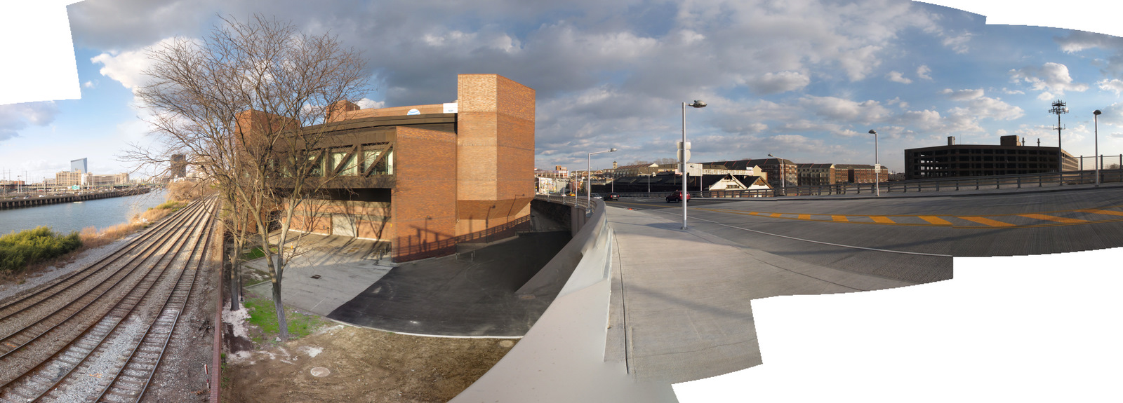
AT&T Communication's Building at 500 South 27th St., from the South Street Bridge.
For those of you in or nearby Philadelphia, the Grid/Flow conference at Temple University takes place this Thursday and Friday, April 7 and 8 (schedule here). Admission is free; the organizers have culled a diverse group of scholars together for conference and it will be an interesting, worthwhile event. I feel it is also important to support these sort of interdisciplinary conferences at Temple University--they bring a dynamism to the campus that is not often present. I will be giving a talk in the 2:30 to 5:00 session on Friday on the infrastructure of mobile communication; below is the abstract I submitted, Invisible Infrastructure: Hertzian Space and Digital Flows of Philadelphia:

The transformation of nature into culture that is continuously producing the contemporary urban landscape occurs through infrastructure.  Modern infrastructural networks—water, electricity, transportation, and communication—course below and above the street-level grid of a city such as Philadelphia, providing the support structures for urban life.  A conceptualization of Philadelphia is not complete without considering these metabolic systems that transform the natural environment into the urban.  While not as vital to everyday urban life as water or electricity networks, telecommunication systems are a vital component of the urban environment. As telecommunication has become untethered to place via mobile, digital technologies such as the cellular phone and the Internet, a new layer of privatized infrastructure has spread throughout the city. These globally networked infrastructural systems of the information society are engaged with via the devices that the end-user holds, such as a mobile phone, while the physical infrastructure remains in the background, effectively invisible.  Bringing these digital communication infrastructures forward, and situating them within the larger, networked urban infrastructure systems of Philadelphia, is a way to ground the material and immaterial flows of digitized information that are central to our networked society.  This presentation will utilize photography and mapping techniques to illustrate the place of digital communication infrastructure within the larger context of Philadelphia's urban environment.  It will highlight the connection this digital communication infrastructure has with earlier forms of transportation infrastructure, seen in, for instance the running of fiber-optic cables along railroad track right-of-ways, putting the digital flows of the information economy in the same location as the material flows of the industrial city.  These digital flows create a hertzian space that effectively commodifies the ether surrounding the air we breathe, transforming a basic component of urban nature into a vessel for a privatized telecommunication network.

AT&T's building at 500 S. 27th St. through an iPhone on the AT&T network. The Grid/Flow presentation will include a case study on this facility.

24 March 2011

homeless camp, broadband fiber optic lines

Underneath Chestnut Street, on Schuylkill Banks. Philadelphia.


Long-haul, interurban broadband fiber-optic lines are often buried alongside railroad tracks; their presence is typically indicated with a white plastic post with a orange or black top that will say "Do not dig here" and "Property of ___ Corp."  We as the end user on a computer or smartphone do not have or need to know what places the data is traveling through to get between our screens and the servers that house the website we are using, but the digital data is moving through space, buried under these markers. In the photo above that I took on late morning Tuesday, there is a small homeless dwelling situated alongside one of these fiber cable markers. Does the inhabitant know what he or she is sleeping on top of? Do they have a mobile phone to access the digital infrastructure that is passing directly beneath them? In this space of motion--information, railroad, and automotive above on Chestnut Street, this temporary camp was situated. This becomes an urban juxtapositions of life in the network society.

reinforced riverbank

The Seine's channelized riverbank. Winter 2008.

16 March 2011

exposed

Lower Manhattan.

13 March 2011

the remains of some digital infrastructure

A stack of discarded servers sitting on the loading dock of 500 South 27th St. in Philadelphia, a large, regional AT&T telecommunications facility. This loading dock sits directly below the sidewalk approach onto the new South Street Bridge. This equipment, waiting to be discarded, indicates that something goes on here, even if very little activity is visible. Rarely are workers to be seen inside the building or outside on the grounds. This building is very interesting in its brick, bunkered anonymity. It has no entrance visible from the street, few windows, and no signage other than an AT&T sign on the roof, visible from the South Street Bridge but not the sidewalk. At the same time, this site is a regional connection point for AT&T's mobile phone networks. Connecting people, in this instance, occurs in a space disconnected from its neighbors, a walled off fortress that is integral in producing and maintaining mobile connectivity.

15 February 2011

11 February 2011

redirecting the water supply onto the streets

38th and Woodlands Walk. UPenn, just east of West PHL.

What happens when water infrastructures fail? In this case, late this morning, 38th St turns into a small river, traffic stops flowing, and everyone stops to watch. Apparently a 20 inch water main broke. All this water diverted out of the Schuylkill River to supply Philadelphia with drinking water, filtered for potability, now returning to the Schuylkill. Note in the foreground of both pictures all the gravel--the water flowing out of the broken main has effectively formed a small, curbside beach for the time being.

28 January 2011

protecting San Francisco's water supply

An owl, off duty and housed at the old baseball field in Moccasin, California.

The City and County of San Francisco is using birds of prey to manage the water quality at Moccasin Reservoir.  The birds and their handlers keep ducks and other migratory waterfowl off the reservoir in order to maintain the quality of San Francisco's drinking water.  These birds scare off other birds that would defecate in what becomes drinking water 150 miles west of this point.  By employing these birds and their handlers, San Francisco reduces the amount of chemicals needed to treat their drinking water.  San Francisco runs their water through filtration systems, but the less pollutants in it beforehand, the less they have to clean it, and the less the City has to spend cleaning it, before it reaches the tap.  The birds housed in these non-permanent fence-structures constitute a living, breathing, and flying, and ecologically-friendly part of the system of water delivery for San Francisco.  This encampment of trailers, pickups and fences represents a support structure for the infrastructure that delivers water to San Francisco.

Birds of prey at rest.  Moccasin.

Moccasin Reservoir.  December 2010. 

27 January 2011

Telecom 450

Gladfelter Hall, 4th floor.  Temple University.