 |
| Water, freeway, electrical power, probably a cellular phone tower or two as well. The Schuylkill River from the South Street Bridge, Philadelphia. |
05 December 2010
corridors

17 November 2010
inclusion/exclusion in the city

From the chapter "Neobourgeois Space":
What novelists like Perec, Beauvoir, and Rochefort -- no less than the Situationists performing their urban experiments in Paris during the same years, or Henri Lefebvre progressively recoding his initial concept of "everyday life" into a range of spatial and urban categories -- realized, was the emergence of a new image of society as a city -- and thus the beginning of a whole new thematics of inside and outside, of inclusion in, and exclusion from, a positively valued modernity. Cities possess a center and banlieues, and citizens, those on the interior, deciding who among the insiders should be expelled, and whether or not to open their doors to those on the outside. -- Kristin Ross, from Fast Cars, Clean Bodies p. 149 - 150What interests me about Ross's point, in the context of mobile connectivity and infrastructure, is how this inclusion/exclusion is reinforced through access to communication technologies. The ease of wayfinding through a mapping app on a smart phone is only useful if you can access the phone and afford the data plan. Is access to a smart phone a new inclusion into "positively valued modernity"? And how is this access opened to outsiders? The urban spaces have not changed much due to mobile connectivity, but the utility they spaces hold changes through on-the-go access to the Internet, for instance, through a smart phone. Perhaps mobile and urban technologies can become more open and inclusive -- here is an example of public usb drives installed in New York City -- but, most likely, inclusion in urban society will necessitate leaving the phone in the pocket, inhabiting the physical city and not the cyber-city, and spending more time on the streets, on foot.
08 November 2010
the invisible city
 |
| One Wilshire in downtown Los Angeles, a prominent colocation point on the west coast/eastern shore of the Pacific Ocean for global telecommunication providers. photo by Xeni Jardin, via flickr source |
Kazys Varnelis's work, especially The Infrastructural City: Networked Ecologies in Los Angeles, is extremely useful for conceptualizing the space of telecommunications. In looking over his essay on One Wilshire in The Infrastructural City again, I found this quote:
If the [Disney] Concert Hall represents late capitalism's obsession with the visual, One Wilshire represents the rise of invisible networks and unmappable forces in our lives. The invisible city that grows from telecommunications is, by and large, a privatized infrastructure, its possession by private forces making it impossible to map. Although the postmodern hyper-space of the Bonaventure [Hotel] is unmappable by the body, a legible floor plan can still be found. No such plan exists for networked capital. Diagrams of the Internet and of fiber optic lines are hard to find: the data is proprietary, a matter too important for corporations to allow free access. Moreover, the complexity emerging along with the massive proliferation of connections increasingly makes it hard for even corporations owning the networks to understand their dimensions. A floor plan of One Wilshire tells you little about what happens there. Even for the corporate hive mind, the map is exceeded by a hypercomplex reality. The space of global technological flows does not desire to become visual or apparent: perhaps only some spray-paint [on asphalt] or a flag in the ground marks the presence of fiber below, and sometimes even that is elusive. (pages 128-129)Increasingly, conceptualizing the spaces of this invisible city require searching through pages upon pages of planning documents unearthed on the websites of municipalities to infer where a fiber-optic cable is run underground and which global corporation is putting it there. This research is done more through identifying the spaces where conditions come together than by identifying the direct points or locations of the telecom infrastructures.
 |
| Telecommunication networking equipment inside One Wilshire. photo by Xeni Jardin, via flickr source |
25 October 2010
live, global locations of cableships
 |
| The locations of the world's submarine fiber optic repair ships, 25 October 2010. Source |
11 October 2010
submarine fiber optic cables attacked by sharks
View Larger Map
In the 1980s AT&T was prototyping submarine telecom cable by laying they between the Canary Islands, where the cables were attacked by crocodile sharks
Buried in the final section of a Rand Corporation study into the feasibility of a new platform for deep-sea submarines, is a chapter about the history of submarine cable infrastructure. In an otherwise dry paragraph about the dangers from dragged anchors and the like that submarine cables face on the ocean floor, was this sentence:
"Between 1985 and 1987, AT&T found that its first deep-sea submarine fiber optic cable (laid between the Canary Islands, Grand Canaria and Tenerife) suffered periodic outages because of frequent attacks of the Pseudocarcharias kamoharai, or crocodile shark, on the cables."
 |
| The crocodile shark. Source |
A footnote goes on to explain that "The electric fields of which, it was thought, duplicated that of the shark’s prey under attack."*
I find this fascinating, and slightly amusing, that the globally networked fiber-optic communication system could be damaged enough to cut out by a shark attacking the cable. Information and communication technologies exist as physical abstractions, of data flows between New York and London's financial centers that dictate the rise or fall of the day's stock trades, and out of nowhere the infrastructure could fail because of a hungry and/or angry shark, at the bottom of the Atlantic Ocean.
*source: Martin, Rick, “Life History and Behavior of Lamnoid Sharks,” from ReefQuest Expeditions, 2001.
10 September 2010
corn fields and fiber optics in the Midwest
 |
| Fiber optic line markers alongside Highway 24 west of Eureka, Il. |
 | ||||
| Stop sign, street sign, and fiber optic cable route marker. Eureka, IL |
 | ||
| Buried gas, sewer, electric, and communication infrastructure, and the overhead electrical lines. Eureka, IL |
What caught my eye and why I stopped to take these photographs, was this scene above, where it appears some digging was scheduled in the near future. The spray paint and mini flags signify all the different buried infrastructure lines. What seemed somewhat unique here was that the flags had the company's name on it. Orange for communication, red for electricity, yellow for gas, green for sewers. This is an instance of invisible, underground systems poking through to the surface, if only for a short time.
 |
| A close up of these utility flags -- gas and fiber optic lines. Eureka, IL |
10 August 2010
a cathedral for electricity
In a space fit for worship lost somewhere in the far, far metropolitan fringe of Northern California, is a decommissioned hydroelectric power plant, the building now used for the storage of dusty, forgotten outdated equipment. The space's original utility was to produce electricity for an industrializing Bay Area and Central Valley, but now it sits vacant, in need of structural repair and earthquake retrofitting.
 |
| The main room of the building. Note the railroad tracks on the bottom left, and all the windows letting in plenty of natural light -- no reliance on electrical lighting even though electricity was being produced in this space. Photo by Alan Wiig. |
 |
| Used Pelton wheel turbines -- hydraulic mining technology now used to generate hydroelectric power. |
 |
| Old signage letters -- look at that font! |
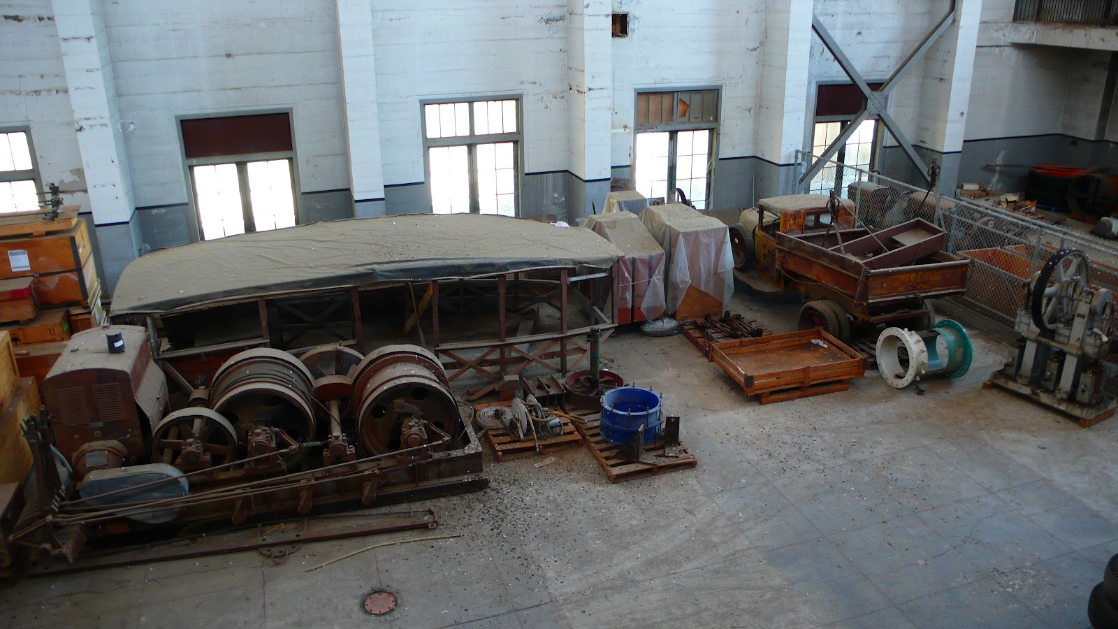 |
| Antique equipment. The truck was deteriorating but in decent shape. The covered frame center left is possibly from a San Francisco horse-car, the pre-cable car form of urban transit that Chris Carlsson wrote about recently on Streetsblog SF. |
 |
| The view of the holding reservoir right outside the power plant. Swallows now roost throughout the building, gaining entry via broken window panes. Their cries echoed throughout the main room during our visit. |
03 August 2010
entry points to the urban underground

Photos taken last winter on the University of Pennsylvania's campus. I was struck by the variety of shapes and sizes of the cast iron circles, as well as how prevalent these access points are around the campus.
Looking at the patterns of squares and circles was, at the time, something to do to distract myself from all the snow that had
recently fallen. Now, in early August, winter seems like a distant memory.
mapping submarine fiber-optic cables
 |
| Telegeography's Global Submarine Cable Map 2010 |
Yesterday, via an article on The Economist magazine's website, I found out about Greg's Cable Map, which is an excellent mash-up of submarine fiber-optic cable landing locations layered onto Bing Maps. The map effectively shows where the Internet enters and leaves each of the continents and most, if not all, of the inhabited islands in between. While the global scale submarine cable map can be seen and even downloaded as a jpeg file at Telegeography's website, Greg's Cable Map is useful because it allows the viewer to zoom in to see the particular cities where the various submarine cables emerge from the ocean floor and connect into the terrestrial Internet grid.
Greg has also provided links to each submarine cable's owner-operator, so it is possible with a little research to see who is routing what through where regarding the major Internet Service Providers. For instance, in Tuckerton, New Jersey, just north of Atlantic City, two cables land, the TAT-14 and the Atlantica 1. At the TAT-14 website, there is a list of the thirty four companies that are partnered with Sprint to use the TAT-14 cable system to route Internet traffic. While this side of the Internet is not slick and fancy, and the websites often appear ten years out of date, the information about the submarine cable systems is interesting and important. It places in distinct space the ephemerality of bits of information traveling over the Internet's global network. In effect, it is the global network grounded in specific locations, like Tuckerton. Amid the sprawl of suburban New Jersey, on the border of the Pine Barrens, is a landing point for a cable that, while anonymous and indistinct, forms part of a global communication network that we all rely on daily. Effectively, Tuckerton is part of the everyday landscape of the Internet that is accessible through the screen of our computer or mobile phone, but also present in submarine cables like the TAT-14.
 |
| Tuckerton, New Jersey, the landing point of two submarine fiber-optic cables. Image taken from cablemap.info |
...a final note -- after looking at the map, I am almost positive that the map does not show the actual location of the landing point. Finding these actual spots would require some fieldwork that I hopefully will be able to begin this fall.
Subscribe to:
Posts (Atom)